(or, what’s wrong with the general purpose map on my phone that just seems designed just to show me adverts?)
I decided to write this after reading some of the comments on the wiki here and in the community forum here.
People tend to view “things that appear on a map” as “somewhere that they can go”. For example here:
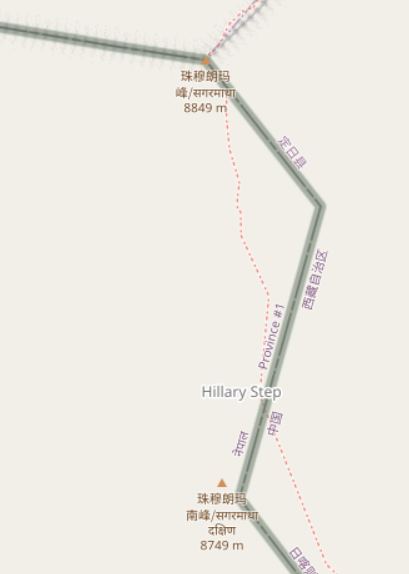
someone who didn’t do their research properly might think that they can just wander along that path to the top of Everest from the south, despite the underlying data suggesting “difficult alpine hiking”. This diary entry is an attempt to try and avoid such misunderstandings.
What options does a map have to different things?
The map at map.atownsend.org.uk shows linear paths and tracks as a single line, It shows legal rights of way (some special categories in England and Wales) and also tries to give some indication of what a walker might expect on that path.
First, before we talk about “showing what a walker might expect”, a note on what options maps have to show linear things differently:
- colour
- width of line
- pattern along the line
- other things drawn alongside the line
How are those shown?
The colour of the line is used for the legal designation - brown for “motor-vehicley” ones, blue for “horsey or cycley” and red for “foot only” and grey for no legal designation, like this:
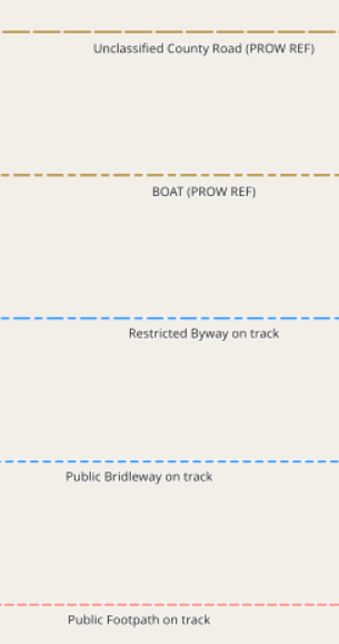
In addition, an overlay colour is used for access rights:
The width of the line is only used to control the “visual weight” of features on the final map - it’s tuned by colour at each zoom level, so that a particular sort of feature does not dominate the map at that zoom level.
The spacing of the pattern along the line shows the width of the path (widely spaced for wider than 2m, narrow spaced for less than):
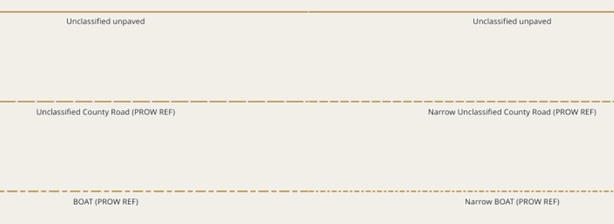
Also, slightly different patterns are used for some slightly different legal designations (for example, bridleways and restricted byways).
“Other things drawn alongside the line” are used for tunnels, long fords, bridges and embankments, for example:

What other OSM tags do we want to show?
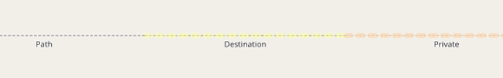
“informal” is sometimes used to show that a path has been created by users rather than by sanctioned by land managers. This only makes sense in places where there are formal paths (which isn’t everywhere), and an informal path isn’t necessarily in any way illegal to use.
“trail_visibility” is used to indicate how easy it is to see a path on the ground.
“sac_scale” is used to show how difficult a path is to use.
The first two are essentially about showing that a particular path might be difficult to see, or that a walker might not want to follow it because it’s not an “official path”; the third is about how to show (and in some cases not to show at all) paths that might actually be dangerous to an unsuspecting walker.
A final tag that isn’t shown is smoothness. Unlike other modes of transport, a low sac_scale path won’t become impassable to most pedestrians because it’s not very smooth.
What is actually the goal of this map style?
It’s designed to show all legal rights of way there is an actual path (theoretical routes exist where there isn’t really a path - the walk across Morecambe Bay is one example).
Paths that are difficult (high SAC scale), informal or not very visible are de-emphasised in the rendering.
Very difficult paths and very poor visibiliry paths that are not public rights of way are suppressed from the default rendering; an overlay is available for these.
What does this mean in practice?
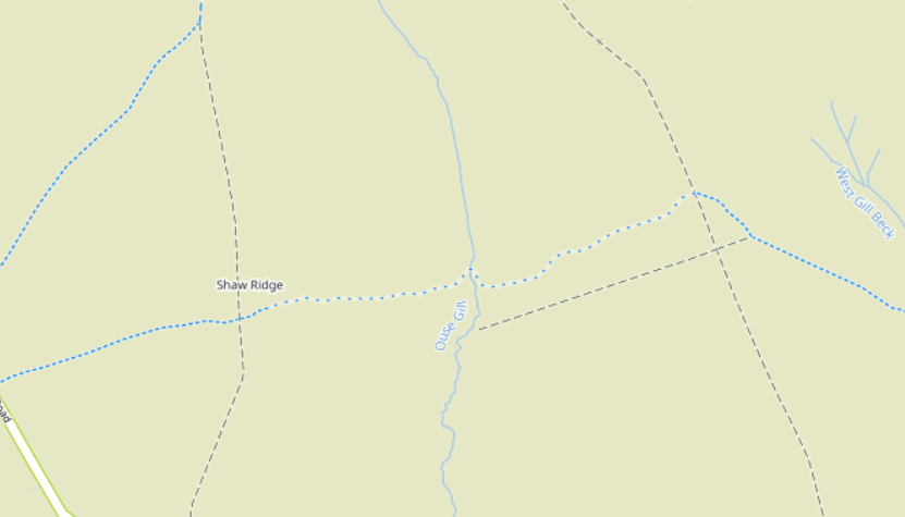
Here’s a section of bridleway in the North Yorkshire Moors with a “trail_visibility=bad” section in the middle:
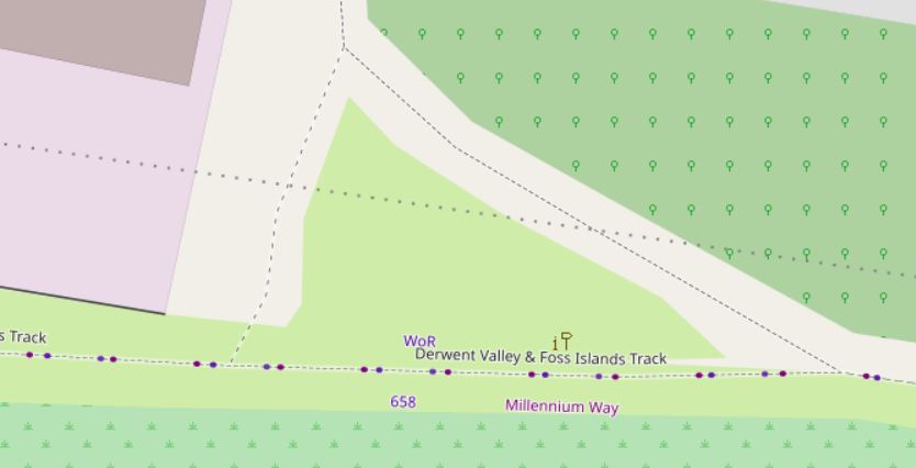
An informal human-created shortcut off the Foss Islands Track in York
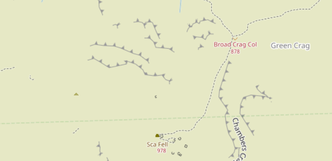
West of Sca Fell, with “difficult” paths excluded by default:
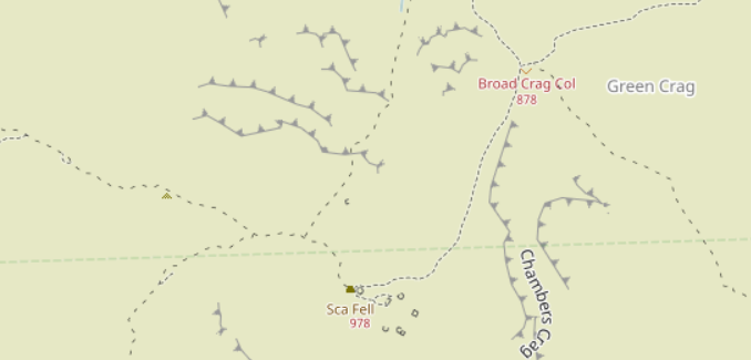
The same view, but with the overlay of “difficult” paths turned on:
The net result is that
- walkers who see a path on the map will see a path on the ground
- paths that are less clear on the ground will be de-emphasised on the map
Discussion
Comment from SK53 on 11 December 2022 at 22:00
I was a bit puzzled why Scafell Pikes had disappeared entirely and Sca Fell had popped up in its place, but it turns out that the trig pillar has been added with an erroneous name. Not sure why you are picking it up though.
The actual sac_scale grading of paths in the area is somewhat overwrought (e.g. from Mickledore to Scafell Pike is not hard).
Incidentally, Scafell Pikes is the only British peak where a companion has said “Bergheil!” at the top. It was a particularly fine day with good quality snow down to 2000 ft which emphasised its character.
Comment from SomeoneElse on 11 December 2022 at 22:13
Zoom in a bit and you can see what is happening:
The “Sca Fell” name is from the trig point, and the “Scafell Pike” name (which is obscured) and elevation (which isn’t) is from the peak.
For “proper mountain-looking mountains” this side of Dover you probably want something like Errigal though…
Comment from Hungerburg on 22 December 2022 at 23:50
I am still fond of this comment on the tagging ML, https://lists.openstreetmap.org/pipermail/tagging/2022-September/065518.html - The interesting content is below the fold ;)
Comment from SomeoneElse on 30 December 2022 at 14:35
Something else worth mentioning is https://wiki.openstreetmap.org/wiki/United_States/Trail_Access_Project#Suggested_Tagging .
When tagging paths such as these, where I differ from what that suggests is mostly as follows:
Aside from those, that page is really useful - including the “Recommendations to land managers” section! Just expecting map producers to tell people where not to go when you have not bothered to sign it yourself is clearly not OK. In the UK one of the biggest relevant landowners is the National Trust, and they’re actually pretty good about this sort of thing.
** The actual suggestion is that “an official path” should be tagged as “highway=path;name=Name of Trail”. Obviously there will be examples where the name of the path IS the same as the name of a route running over it, but even from my experience in the Western US, it’s rare.