In England, the Environment Agency has an extensive network of river level monitors that are used to provide flood warnings such as (at the time of writing) this one.
However, these alerts tend to be only issued when land or property is likely to flood, and there are many paths that flood much earlier. An example is here, where if the downstream station reads just over 1m, you’ll get your feet wet. The Environment Agency doesn’t issue a warning at that level because it’s well within the normal range, and the river’s still well within the levees that have been provided for it for the last 50 years.
It’d therefore be useful to know which paths are likely to be flooded, and this can be done by noting what upstream and downstream measured levels were when a path was or was not flooded. In this case the downstream level is the more reliable indicator since lots of land drains empty into the river below the upstream station and there’s nowhere for the water to go before the downstream one. This has to be done on a case-by-case basis; EA’s flood maps are great for predicting low-level land that’s at risk but don’t have enough granularity to help here.
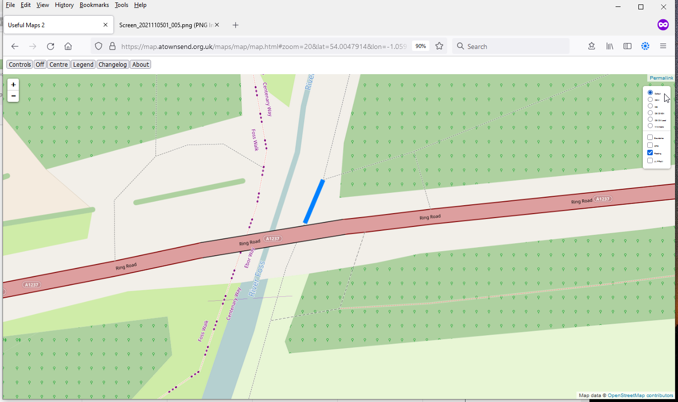
I’ve done this here. The map is a simple overlay available at https://map.atownsend.org.uk/, and it’s currently using the same database as the normal map there. The “is it currently flooded” information is obtained from EA’s station information every few hours (and station data is cached locally to avoid multiple unnecessary reads of that site). When a path is flooded, it shows in blue, as can be seen above. The overlay tiles are removed before each resample to avoid any tile caching issues. This map isn’t designed to replace EA’s own maps - when there are warnings of property flooding many areas where I’ve never measured “path X floods when station Y reads Z” will be affected.
Currently the comparison data is in the script itself not in OSM - I did ask about how it might be possible to do that earlier, but the replies seem to mostly miss the point that I was actually already recording “is it flooded or not here” rather than just guessing current flooding issues based on EA station values. It it proves useful to add more data it might be worth moving the comparison values into OSM itself (in the spirit of “any tags you like”), but that’s not a priority.
This approach won’t work everywhere. Nearby, Clifton Ings is one of many areas regularly deliberately flooded as part of flood prevention measures, but someone literally has to open a barrier to let water in and open another one to let water out - and presumably that is based on a mix of current and predicted future rivel levels, in turn based on previous and predicted rainfall elsewhere.
Discussion
Comment from Feyman Diagram on 3 January 2022 at 20:24
A walk I did recently with the guidance of OSMand had me got along a dirt footpath but at this time of year after some rain… Well wellies would of been better foot wear. I think walking navigation should add warnings to walking directions on footpaths after recent rain/flooding so that the end user can decide an alternative path.
Comment from SomeoneElse on 9 January 2022 at 22:21
Hello Feyman Diagram,
There’s not a good way currently of mapping “this place might get muddy after it rains”, the nearest we’ve got are tags that describe the surface (like “surface=dirt”, “tracktype=grade5” etc.).
We do have tags for intermittent water and flood-prone areas, which might work in a few places, but not really “this might get muddy”.
However, tagging things with actual surface is a huge step forward.
Best Regards,
Andy