
This week I’ve released the 2.0 version of Every Door, which irons out most of the inconveniences found within a month after its official release. Yes, the editor has been officially released, just a few days before two talks on it at SotM and FOSS4G (recordings pending). You should download the editor for your Android or iOS smartphone right now!
I absolutely love the experience it gives me. It has revived my love for plain mapping, going out and collecting things to put on the map. Pascal’s HDYC shows my mapping days went from 29 last year to over 120 this year. That’s because I again look around for unmapped things while outside, and making an edit no longer requires navigating a map on a small phone screen, or making scribbles to open JOSM later at home.
Looking at amenities mapped with Every Door, I feel that few mappers understand the power of the editor. My intention for it was to have most if not all shops and amenities mapped on OSM, to make our map better than proprietary alternatives not only wrt cycleways, but for everyday tasks like finding which flower shop is open at 8:30. This is a huge endeavour, as I see having mapped over a thousand shops in Tallinn and around Riga.
To do this, to have everything on the map, we need to adjust our mapping habits. “Record and map it later” would not work: later never happens. “Confirm this one attribute” does not work either: the map is missing everything, everywhere, always. We needed an ultimate tool to record as much as possible as fast as our fingers allow. Finally, there is one.
But to leverage its power, one must learn how it’s different, what to look for. Every Door is by no means simple. It’s not a novice-friendly editor like StreetComplete or iD: it needs getting used to. Training. Tutorials. I plan to maybe record a few videos on that. But today I’ll share the basics: how I use it on any day I see a shop or a restaurant.
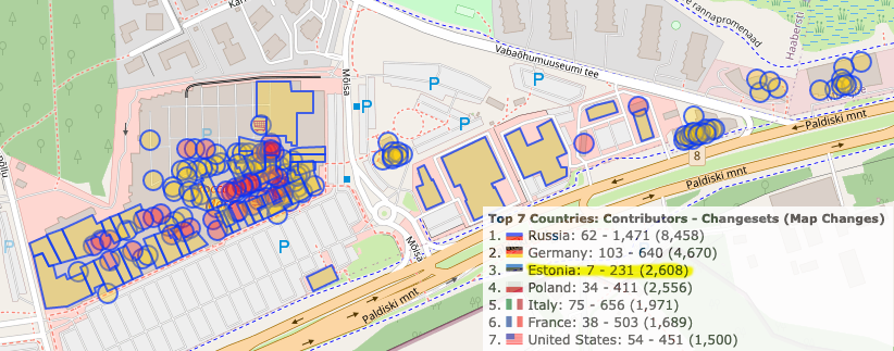
On this picture you see the statistics for mappers and number of map changes made with Every Door in the last month. Estonia stands out: indeed, that’s where I live. Most of the changes are mine. But I’m not mapping every day: far from that. I’m not a hardcore mapper, I just like to add things to the map. I spend like couple hours a week on mapping. But there are two key things that enable me to collect data effectively.
First is time. There is always time. The bus comes in ten minutes? Great, let’s walk around the block and map building heights and entrances. Stuck at a playground with your child? Half a hundred micromapping edits for everything you see — easy. Have a spare hour returning from an event or waiting for somebody? Open the editor and walk into every shop and shopping centre along this main road.
And also dedication. Focus. When you’re mapping, it’s like learning a poem, or reading an article in an unfamiliar language. You do the same thing over and over, you look up new words and write them down. Mapping is getting to know your city over and over again. It’s learning it afresh. Every street and every building. Noticing and mapping every door.
You can see this on the picture again: that’s Overpass Turbo results for things I created or confirmed mostly on a single day, during my two hours of mapping. All offices in two office buildings, all shops around, everything in a shopping mall. Before Every Door, I just tried to remember or made a photo, to map at home. Photo mapping does not work. Mapillary mapping does not work. Your changes need to be done there and then. See something new? Open the editor, do a few clicks, and you’re amazing.
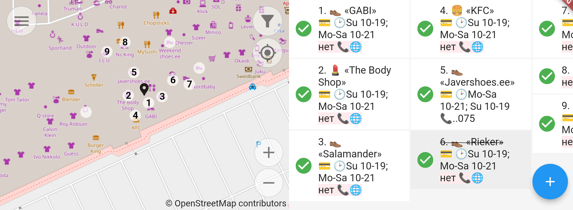
It’s simple, really: start with the “POI” mode, marked by a tea cup. Confirm or adjust your location with the map — do not zoom, just drag it if needed. And study the list of amenities below. Compare it with what you see around you. Spot the differences — and record them. Tap on cards to add opening hours or contact details. Tap (+) to add a missing shop. You can be sure what’s in the list is the 100% complete and correct representation of what’s in OpenStreetMap: if a shop is missing from the list, it’s missing from the map. Do add it.
Then it’s the same checklist: location, name, opening hours, wheelchair accessibility, payment options, optionally phone, website, operator. Should take you like twenty seconds. Save and proceed. Second, third, tenth shop. It took me 2.5 hours to map the second biggest shopping mall in Estonia the first time.
And it takes me under half an hour to walk it again to confirm everything. Confirmation is important. The check_date tag is important. Otherwise you cannot tell the probability of a shop still being there. Was it edited a week ago, or was it an automated edit for an object surveyed in 2010 and long gone?
In Every Door, when you see an amenity and you see that it’s mapped correctly and still there, you tap the checkmark. See these green checkmarks on the top picture? These are shops confirmed in the past two months. If a checkmark is black, and the shop is there, tap it. It’s a proper edit, it adds to your edits count and conveys important information to map users. When you’re not up to entering data, just confirm everything. It’s just a tap, and it’s as useful as answering a question in StreetComplete or clicking your way along a river in iD.
And that’s basically it: have the editor at hand, know how much time you’ve got, focus on mapping your city, use the POI list to validate amenities and fix the differences, and confirm POI that are mapped correctly.
I hope some of you would share my passion for mapping — not abstract mapping like collecting photos and not opening an editor, not automotive mapping, not tracing satellite imagery, but the mapping as it was done in early days of OpenStreetMap: just going out and adding everything you see with your hands onto the map. It benefits you, since you get to know corners of your city you didn’t know existed, and it benefits everybody else by having recent and correct info about all the shops and amenities in their Organic Maps or OsmAnd. Let’s get back that POI power from Google and Apple!
Discussion
Comment from wille on 14 September 2022 at 12:25
Congratulations and thank you for this awesome app! I mapped a lot while travelling in Portugal in the last weeks, and it’s really powerful.
Comment from mvexel on 14 September 2022 at 19:23
I’ve started to use Every Door a little bit and like it a lot. Ilya is right, it takes bit of getting used to. But I don’t see another way currently existing that can do more to ensure we’re going to 1) get all the POI in OSM and 2) important! keep them updated.
About “later never happens”, I think you’re generally right, if you’re just speaking for yourself. For MapRoulette I have the idea to connect the “now” of mappers out on the streets with the “later” of armchair mappers. That can be a different person. The mapper on the street would, for example, take a picture. And the mapper at their desk, using MapRoulette, could add the information from the photo to OSM in turn. I’m not sure about this feature yet but would like to get some opinions on why it would (not) work.
Comment from mvexel on 14 September 2022 at 19:26
sorry for the dupe. browser and me acting weird at the same time?
Comment from Zverik on 14 September 2022 at 19:43
Gah, we should have met at SotM to talk this “now”-“later” thing in MapRoulette over! This is like a thing that calls for a brainstorming. I have tons of experience with making photos and scribbles for the map and never coming back to them. But I’m not sure if MapRoulette’s model fits. And that we would get many people processing the collected data: walking and making photos is miles more fun that sitting in a room and adding the data.
Comment from mvexel on 14 September 2022 at 19:53
Yea I wonder about that. I am sure there are people who would rather sit at their computer and add info to OSM based on a picture someone else took than go out and survey. To each their own :)
My thinking about this goes in the direction of creating connections. Linking the mapper who took the picture with the mapper who added the data to OSM using the picture. Even if it’s just clicking a button that says ‘give thanks’ (like you can do on the OSM wiki for example. Then, a relationship is created that makes both contributors feel good, and encourages them (hopefully) to keep doing what they are doing.
MapRoulette in its current form may not be the best ‘platform’ for this, but I am thinking about the next major version of MapRoulette, and I am open to it looking quite different from what it is today.
Comment from Firefishy on 14 September 2022 at 21:17
Every Door v2.0 isn’t yet available in the Google Play Store. Is Google worried about this awesome OpenStreetMap mapping app?!? ;-)
Comment from Zverik on 15 September 2022 at 06:13
Hey Grant, it’s still in review :( Google is notoriously slow with reviewing app updates. AppStore version was up the next day after I submitted it, on Sunday.
Comment from Zverik on 15 September 2022 at 06:16
Martijn, making connections is a great idea. Like a line of indirect positive communication: “hey your data has been mapped by X, do thank them” → “Y has seen you mapping and is very grateful”. Also, archievements! And tutorials for collecting data better, like what exactly to photo, how to convey context, how to submit walking papers. Maybe also package all of that for each surveying session, so that one can submit some photos and a hand-drawn map of where they are.
Comment from mvexel on 15 September 2022 at 14:59
Those are great suggestions!!
Comment from benoitdd on 16 September 2022 at 08:08
About the work with pictures, pic4review might be interesting. I don’t know if you can create a mission with a specific set of your own pictures.
Comment from amapanda ᚛ᚐᚋᚐᚅᚇᚐ᚜ 🏳️🌈 on 21 September 2022 at 09:24
I’ve started using EveryDoor, and it’s fantastic. Like StreetComplete, it allows me to map way more things, way more quickly. OSM needs more PoIs. I’ve been adding loads of PoIs and updating them. It’s great.
I don’t think “later won’t work” is right framing. Some people work later, some work only in the moment. EveryDoor opens, and helps, different ways or mapping. I think there is a lot of “people not OSMing yet”. Tools like this help.
Comment from Zverik on 21 September 2022 at 10:41
Thank you Amanda! My “later won’t work” was in the context of, “collect data now, map later”. Which I can tell from my experience seldom works: ain’t nobody got time for that. Just “map now”, whenever that “now” can happen for you. When your job is done, it gets harder to procrastinate :)
Comment from amapanda ᚛ᚐᚋᚐᚅᚇᚐ᚜ 🏳️🌈 on 21 September 2022 at 10:47
Oh some people can collect data & map later. I know I can’t! 😅😅😅
Comment from Binnette on 25 September 2022 at 07:00
Hi Ilya, Martine, about the ‘map it later’. It also do not work for me. So at least I take the picture with Mapillary app and upload it directly before forgetting it. That way, if ‘sometime’ someone wants to map the area he/she will have a picture (but probably outdated…)
Better is to open StrretComplete and create a note with some pictures. This is nice. Note are more ‘visible’ than a simple Mapillary picture.
I am waiting for EveryDoor to have the same ‘note+pictures’ feature.
I think I can probably create a MapRoulette challenge that notes created by StreetComplete and EveryDoor. Those note were created by people that can fix issue on the field or don’t have time/motivation to do it (do it later). So someone that open MapRoulette have more time and can address those issues 😇👍
Have a nice day and thanks again Ilya for EveryDoor. I give it a try yesterday. The Opening Hours entry system give me a hard try but now I understand how it works. I will create a GitHub issue to add help in app FAQ or so.
Comment from risturiz on 27 September 2022 at 15:04
Everydoor user from beta here :-) … Fabulous app ( thanks for Notes support ), i didn’t understand the “check_date” until now … I see the “Map it later” option for collaborative mapping and we have people that don’t want to map at all but take a picture to confirm some POI ( or add Notes ); this data is useful and don’t require any experience “win-win”.
Comment from John Gilmore on 21 September 2023 at 04:19
Rob Savoye turned me on to Every Door, and it’s great but it’s also super frustrating. It has no documentation and is definitely not intuitive. Thus it’s probably a powerful tool but ordinary people like me can only access about 1% of its power.
Simple things like “move the map display to my current position” don’t even seem to be provided. It seems to jump me to the last place that my GPS was used by some other app – and then get stuck there and never move again. (My GPS is configured to NOT use cellphone sites nor wifi access points, because those methods report my location to a central server, so it often takes seconds or minutes to get an initial GPS fix.)
Zverik’s tutorial here (the first one I’ve seen, and the only one that seems to exist) seems to make the assumption that you will always be editing in some small area near to the last place you edited. So moving the map manually is easy. That assumption isn’t true for me. I map places that are 100 kilometers or more apart, often mapping in cities that I travel to on airplanes. I’m not going to scroll the map manually from Denver to Chicago. Instead, I just get frustrated and quit the app if I can’t get it to show me the shops that are right in front of me for editing. If there is some function for “go to current position”, please un-hide it from the interface, or document it. I even found a crosshair in a circle, hiding under the Tree icon, but it appears only if I scroll the map. Now that’s obscure.. But even then, pressing it doesn’t take me to my current GPS position anyway!
I can’t even figure out how to do the thing it was built to do – map every door. There’s a building near me with a service entrance. I have no idea how to use the interface to map the service entrance to the building. The interface for that doesn’t seem to be hiding under a tree, it isn’t a coffee cup, it isn’t a house, it isn’t a clipboard, it isn’t a folded map. Those are the only things in the GUI except the + button and the menu button that just leads me to the “Settings” menu. I tried the + button, but after picking a location, it wanted me to enter a “comment”, whatever that is, so I canceled. Use words, please: write a tutorial or a reference manual.
There is a setting “Use Google-enhanced Positioning”. Like everything else, it’s undocumented. Does it report where I am to Google? I don’t know, so I turn it off. It might be nice to have enhanced positioning, today I’m in New York City and GPS doesn’t work very well around tall buildings, but I wouldn’t use this at the expense of my personal privacy. Maybe it doesn’t violate my privacy. How would I know?