
🚸 AI-Powered Pedestrian Crossing Mapping: A Revolution
Posted by NorthCrab on 3 August 2023 in English. Last updated on 15 August 2023.🗺️🦀 Hello OpenStreetMap community,
I am excited to share with you my latest invention, osm-yolo-crossings — a new tool that harnesses cutting-edge AI technology to autonomously detect and map pedestrian crossings (zebras) in OpenStreetMap. After the successful AI building import in Poland, it’s now time to expand and improve pedestrian safety!
Leveraging the power of YOLOv8 object detection, this tool is designed to ensure that we no longer miss pedestrian crossings on our maps. With an impressive >99.7% precision rate, it’s able to import around 88% of all detected crossings. The tool discards the remaining 12% due to low confidence levels. Thanks to smart filtering, this system is incredibly efficient. For instance, it can map the entirety of Poland in just about two months using a single server without GPU. This is AI working smart, not hard!

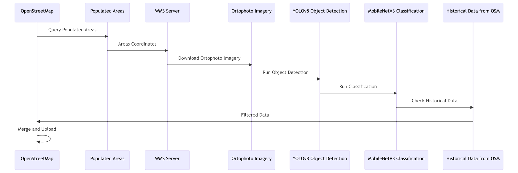
One of the key features of this tool is its ability to cross-reference historical OSM data, which helps avoid duplicate entries and ensures cleaner, more accurate maps. Once removed crossing will not be re-added for a few years. I prepared a simplified workflow diagram, to better visualize the complete process (view in full screen):
The core principles of my projects are transparency and teamwork. As such, this project is released on GitHub, as a fully open-source - and free (as in freedom) - software! Please support it with a star ⭐️ or/and donate here 🙂.
Discussion
Comment from SimonPoole on 4 August 2023 at 07:15
This isn’t really a new idea, we (HSR/SOSM) ran a Maproulette challenge generated from AI identified pedestrian crossings back in November of 2016.
Comment from SimonPoole on 4 August 2023 at 07:20
See http://lists.openstreetmap.ch/archives/list/talk-ch@openstreetmap.ch/thread/UWA3J7GEVDO6WEX4XHL65AFXNP5MS5J2/
Comment from NorthCrab on 4 August 2023 at 11:21
@SimonPoole This is indeed quite a similar project. Thank you for sharing it with me; I was not aware of it. However, I still believe there are some key differences that differentiate my project. YOLO Crossings is open source, allowing anyone to build on top of it and use it. On the other hand, I could not find the source code for the Zebra Safari project, but this could be due to a language barrier.
Secondly, YOLO Crossings is optimized for fully autonomous mapping, with a very high precision threshold set to avoid adding false positive crossings. While it may not map all crossings, it significantly reduces the amount of work required by mappers by automatically marking easy and medium difficulty crossings.
Comment from SimonPoole on 4 August 2023 at 12:08
Naturally a 7 years old project will have lots of limitations compared with something recently created, that wasn’t the point.
Comment from NorthCrab on 4 August 2023 at 12:17
@SimonPoole What was the point? I did not get it, sorry.