
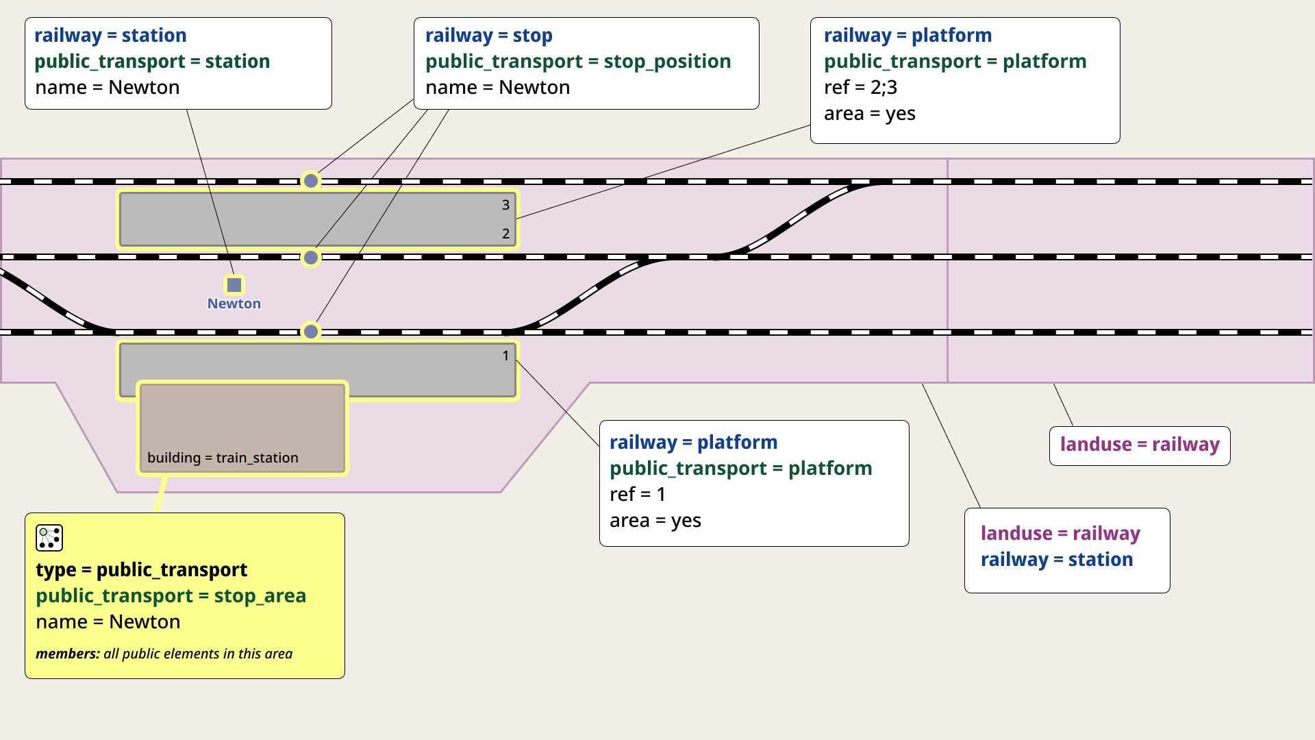
I’ve suggested an updated version of the diagrams explaining the tagging of railway stations. The goal is to make them simpler to understand, especially for newcomers, without losing the core meaning. There have already been some feedback and interesting ideas for further improvements.
I invite you to join the discussion — your input would be highly appreciated!
Discussion
Comment from Endres Pelka on 13 April 2025 at 12:26
I think the railway=stop nodes should habe their ref=* tags too.
Comment from perenniallylate on 13 April 2025 at 13:35
I have basically no experience with railway tagging, but this is a really solid graphic, especially when compared to the old ones. Much less visual clutter and the fact that its close to the rendering of OSM makes it good. Would love to see them on the wiki soon!
Comment from darkonus on 13 April 2025 at 13:56
Endres Pelka, regarding your comment — I’m not sure if that’s the right approach. You might want to ask some of the more experienced members in the thread.
perenniallylate, glad you liked it, thanks for the support! For now, we’ve agreed not to rush with updating the diagrams so that everyone has a chance to share their thoughts.
Comment from Brickblock1 on 13 April 2025 at 14:07
My understanding is that Public Transport mapping relies on stop_position and platform have either the same ref or local_ref, where local_ref is prefered due to it not conflicting with other tags. it might also be worth adding railway:ref to the station and possibly the stops too.
Comment from Carto'Cité on 14 April 2025 at 14:50
Nice diagram, very clear. However my understanding is that
public_transport=stationcan either be a node or an area that covers the station, and more than 40000 are mapped as an area (closed way). Your diagram suggests to uselanduse=railway + railway=stationinstead. This makes sense however this implies a change to the model that should probably be handled through the proposal process.Comment from darkonus on 14 April 2025 at 16:01
The diagrams are still a work in progress, and the discussion will probably go on for a few more weeks. I’m mostly focusing on the design and layout side of things — the actual tagging decisions are being figured out by others who know this topic better than I do.
Feel free to join the discussion here and share your thoughts.
Comment from Koreller on 16 April 2025 at 16:24
Very good diagram, nice work !
Comment from RedAuburn on 27 April 2025 at 10:55
This looks great! Thank you for your work :)
I believe that railway=platform_edge[1] has entered common usage, it might be good to include that as well?
Comment from darkonus on 27 April 2025 at 14:05
@RedAuburn, I read the wiki and thought about your suggestion on how to reflect this in my diagram. However, I feel that adding it would make the diagram overloaded and cluttered with too many labels. In my opinion, the diagrams in the railway=platform_edge wiki article are already detailed and clear enough.
Thanks for your kind words and support!
Comment from tordans on 28 April 2025 at 07:11
Visual feedback: I did not understand the relation part the first time I read the diagram. Suggestions: - remove the yellow line from the relation info box to the object and rely on the border color only. Or add a line to all the objects that have a border. Having only one line suggests that this is a info box for only one object. - write out the „RELATION“ kind next to the icon or replace the icon. The icon is too obscure for inexperienced users. - does „all public members“ mean „only add public objects in the given are as members“?
Comment from darkonus on 28 April 2025 at 14:14
@tordans, thanks for the feedback! I’ll try to implement it in the new version of the diagram. In the meantime, please check out the current version in the OpenStreetMap community discussion thread. Feel free to join the discussion there, as the version posted here is already quite outdated.