
Mapillary をOSMマッピングにオススメする10の理由 / 10 reasons why I recommend Mapillary for OSM mapping
Posted by higa4 on 29 March 2015 in Japanese (日本語).Japanese / English
1. マッピングの事前準備が不要
- 私は旅行や出張で乗り物から外の風景を眺めるのが大好きなのですが、実は風景を眺めながらたいてい建物、道路、河川などを心の中でマッピングしているマッピング中毒者です ;) あなたも普段行かない場所に行ったときにそわそわしたことはありませんか?そんなときの心強い味方が「Mapillary」です。手許に「Mapillary」をインストールしたスマートフォンさえあれば、事前準備無しにOSM編集用の素材として写真を撮影してMapillaryのサーバ上に残すことができます。
1. No preparation required for mapping
- I like watching the landscape from public transportation when traveling. Telling the truth, I am always mapping in my mind watching the landscape such as the shape of the building, river, road etc. Yes, I’m an addicted mapper ;) Don’t you feel fidget when visiting a place without field-papers where you have never been to? Mapillary can help you in such cases. All you need is a Mapillary installed smart phone only. You can leave materials for OSM editing as photos without preparation.
 -車窓の風景 / Landscape from a train (image by Mapillary/CC BY-SA 4.0)
2. 簡単操作
- 操作は極めて簡単です。アプリを起動して撮影モード(歩行、自動車(連写)、パノラマ)を選んで写真を撮るだけです。wifiの接続を検知すると自動的にサーバへのアップロードが始まります。通信コストや速度に問題が無い場合は設定により3G回線からでも送信することができます。
2. Easy to use
- Operation is super easy. Run a Mapillary app, select shooting mode and take a ptoto. That’s all. Mapillary app will upload photos automatically when a wifi connection is detected.
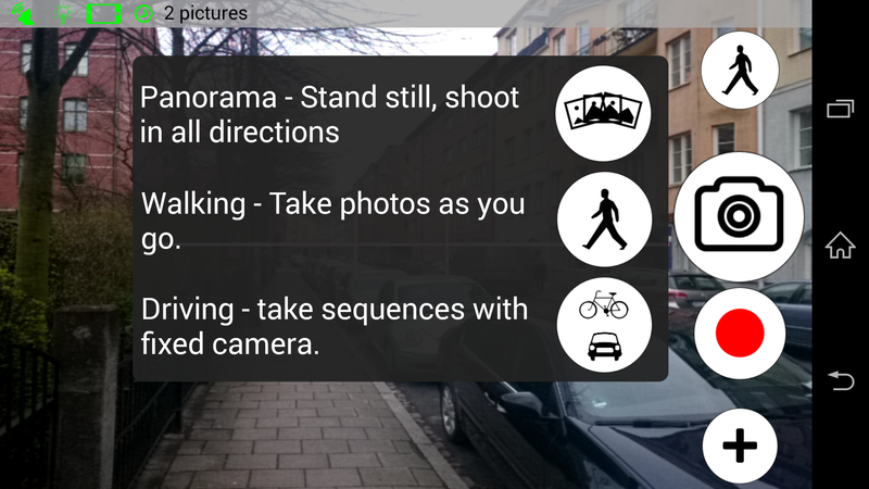 - android向けアプリ / Mapillary app for android
3. 容量を気にする必要が無い
- スマートフォンで撮った写真はあっという間にDISK領域を圧迫しますが、Mapillaryのサーバ上に置いておけば容量を気にする必要がありません。ただし、その写真をOSMでの編集に使用するのと同時に、CC BY-SA4.0の下にオープンデータとして公開するのが前提です。
3. No need to care about local storage capacity
- Photos taken by smart phone sometimes press storage capacity. But when using Mapillary, you don’t need to care about local storage capacity after uploading. But be sure that your photos will be used for OSM editing and licensed under CC BY-SA 4.0.
4. 写真参照機能がエディタに組み込まれている
- 例えばiDでは 「 Map Data > 写真の重ね合わせ(Mapillary)」 をチェックすると利用できる写真が金色のアイコンとして撮影方向付きで表示されます。 クリックすると写真が固定表示されるので、既存のマッピングオブジェクトや衛星画像などで位置関係を確認しながらマッピングします。 つまり撮影してアップロードするだけで特別な操作なしにマッピングが始められるのです。
4. Embedded function for showing Mapillary photos within OSM editor
- In the case of iD, check “Map Data > Photo Overlay (Mapillary)” . Then, you will see available photos for mapping as gold icons with bearing of the exposure axis. When clicking the icon, you can see a photo and begin editing. In brief, you can start OSM editing after taking photos and uploading without complicated operations.
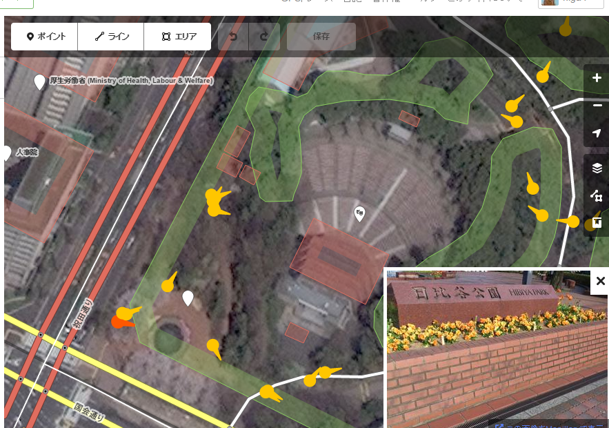 - iDでの表示例 / mapillary on iD
5. 他のマッピングに再利用できる
field papersなどを使ったマッピングでは主に自分の興味や目的にフォーカスした地物を紙に書き込んで行きますので、それ以外の地物は記録に残りません。 しかしながらMapillaryで写真として残しておけば自分以外の誰かが同じ写真を見て、まだ地図化されていない地物をマッピングすることができます。 例えば商店街のマッピングをするために撮った写真はバリアフリーに興味ある人なら店舗の入り口や歩道の段差、階段などはとても重要なマッピング対象です。3Dに興味ある人なら建物の階数もマッピングしたいはずです。建物の種別(住居、学校、商業施設、etc)を細かく区分するとその町の人口を、細かいメッシュで推計することにも使えます。
5. Reuse for other purpose mapping
When using fiels-papers or a pushpin app, you only record what you want to map. On the other hand, when using Mapillary, you can share photos on iD or Mapillary. Therefore someone else may use the photo for other purpose of mapping such as wheelchair mapping or 3D mapping.
6. タグ付けできない、あるいは難しい情報の記録
タグで表現しきれない情報も写真として残るため、エディタやMapillary上で位置情報に紐付く形で閲覧することができます。タグ付けに迷うような場合も、fixmeタグと写真を残すことで、後日自分あるいは他のマッパーがより良いタグ付けをする手助けとなることができます。
6. Combination with fixme tag
You can use Mapillary photo in combination with fixme tag when you don’t have confidence for the tagging. Some other mappers may be able to improve it.
7. 時系列
Mapillaryには同じ位置で撮った写真を時系列でフィルターを掛けてマップ上に表示する機能があります。OSMでは4Dのタグ付け方法はまだ確立していませんが、定点観測のような形で写真として残しておけば将来、時間軸を考慮した4Dマップで利用できる可能性があります。
7. Time series
Mapillary has a function to show photos with the use of time-scale filtering. Although the tagging scheme for 4d has not established yet, it would be helpful for future 4D mapping if you leave photos just like a fixed point observation.
8. 撮影者と編集者の分離
マッピング・パーティなどでIT技術に詳しくない方にとってOSM編集は独力で続けるのは難しい場合があります。そのような場合、Mapillaryによる写真撮影チームとOSM編集チームを分けることで、参加者の裾野を広げることができます。
8. Separating photographer from OSM editing role
Sometimes it is difficult for non-tech persons to edit OSM continuously for themselves when having a mapping party. In such cases, you can expand the range of participants by separating the role for mapping into photographers and editors.
9.オープンデータの写真として利用できる
投稿された写真はCC BY-SA4.0でライセンスされるのでオープンデータとしてOSM編集以外にも多方面に活用することができます。
9. Use as opendata photos
You can use the uploaded photos for any purpose under CC BY-SA 4.0 license other than OSM editing.
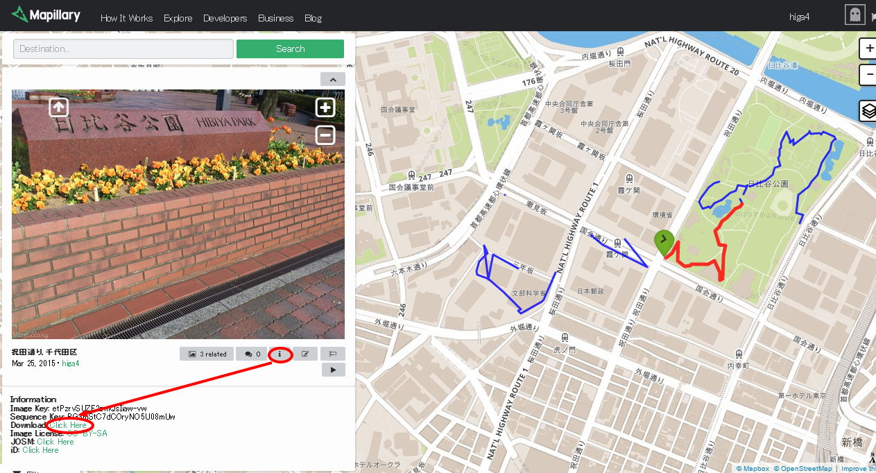 - Mapillaryからの画像URL取得方法 / How to get an image url from mapillary
10.uMap連携
サーバ上にある画像のURLはMapillary上で取得できるので、imageタグとして登録したり、uMap上のURL付加機能を利用して写真付きのマップを簡単に作ることができます。 以下は写真URLをimageタグとしてOSMに登録し、uMapからOverpass API経由で動的に読み込んだ例です。
10. Combination with uMap
You can get the image url from the Mapillary website, so you can add the url as an image tag or add url directly on uMap. Below is a example of combination with uMap and Mapillary photos. Image urls are added onto OSM using an image tag, and POIs are shown via overpass dynamic request.
Discussion
Comment from Rps333 on 29 March 2015 at 08:22
I agree, I love using Mapillary and OsmAnd+ when I’m mapping on the field.
Comment from higa4 on 29 March 2015 at 09:38
Thanks Rps333.
Comment from glibbertorsten on 29 March 2015 at 09:43
Very nice Blogpost. I never could imagine why to use Mapillary - now i know! Especially how to use when editing in ID. Thanx!
Comment from JLZIMMERMANN on 29 March 2015 at 11:31
Thanks for this nice post !
Comment from higa4 on 29 March 2015 at 14:29
Thanks for comments. Have a nice weekend!
Comment from ikiya on 30 March 2015 at 01:17
Thanks for this nice post ! Mapillaryについてのまとめありがとうございます。
9番目のuMapとの連携についてですが、 ”写真URLをimageタグとしてOSMに登録し、uMapからOverpass API経由で動的に読み込んだ例です。” ここの「Overpass API経由で動的に読み込んだ」を概略、教えていただけますでしょうか。宜しくお願いします。
Comment from higa4 on 31 March 2015 at 08:24
uMapの各レイヤの設定の中に「サイト外のデータ」というところがあります。 そこでURL文字列内にAPIの内容を記述します。 例えばトイレレイヤには以下のように記述されています。
URL: http://overpass-api.de/api/interpreter?data=[out:json][timeout:25];(node“amenity”=”toilets”;way“amenity”=”toilets”;relation“amenity”=”toilets”;); out body;>;out skel qt;
フォーマット:OSM 表示開始するズームレベル:17 ダイナミック:チェックあり ライセンス:ODbL
上記のように記述すると、マップを表示するタイミングでOSMデータベースより該当データを抽出します。(常に最新データを読み込んで表示します) OSM以外で提供されているAPIもフォーマットが合っていれば読み込めるはずです。試していませんが。
<関連記事> http://www.mappa-mercia.org/2014/09/creating-an-always-up-to-date-map.html