OpenStreetMap logo OpenStreetMap

-karlos-'s Diary

Recent diary entries

OSMgo.org roof:type=gabled

Posted by -karlos- on 18 April 2025 in English.

Once I had a concept to render gabled roofs in 3D with OSMgo.org but it did not work. Often the roof looked like broken down. After a long time of abandoning OSMgo, I found a “working” solution and used it in my code. But no, the browser got stuck in an infinite loop %-(

May be update the version of ThreeJS, after years? That took me many many hours. For the geeks: Using es6 needed much export and import. After hours of typing, I fond at last VS-Code plugin to show me the missing variables. Not using “with” any more needed a lot of “this”. Worse, ThreeJS dropped the geometry.merge() and changed the geometry attributes, typing, typing. Hey, something positive!: Because now Vertex-Colours are used, only one Draw-Call per 3D-tile is needed. OSMgo should run faster now.

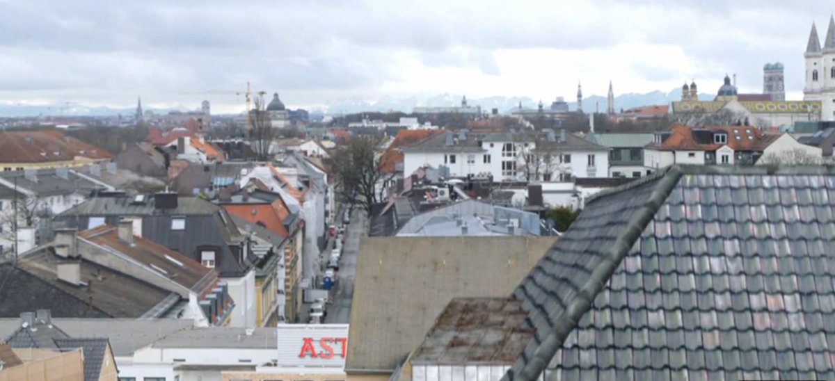
With the new ThreeJS the infinite loop was gone, but: the roof was at the wrong place and direction. Some adaptions of the theft code were needed. Now, the City of London looked much better than before. Oh wait, all roofs were mirrored, one more adaption.

See full entry

Panoramax in "OSM go" / 3D rendering

Posted by -karlos- on 5 February 2025 in English.

Panoramax is a rising star at the moment, for OSM, but not only; while Mapillary goes down, sold to Facebook. In my old www.OSMgo.org, the key P showed a Mapillary picture near the actual position in the 3D rendered OSM world. As the API is gone, I replaced it with Panoramax. OSMgo was abandoned by me years ago but the server is still running. As I read more and more about Panoramax, I decided to dig out the old code and use it. First I asked in the Fediverse for help with the API and got a great and fast response, even a good example, thank you all!


There are almost to much pages about it. The real API was a bit hidden but well documented at last. The Idea of decentralised servers but a central directory is great, the Web-UI to see all pictures to. And the API got me a json list of the closest pictures, including a link to the pictures. After researching to define the radius (place_distance) and get the direction of the “shot” (feature.properties[“view:azimuth”]) my old Mapillary could be modified to show the picture in the 3D view and move the camera to see it.

Try it out

See full entry

Location: Westminster, Millbank, City of Westminster, Greater London, England, SW1P 3JX, United Kingdom

Das Thema ist mir zu komplex, um es (gleich) in englisch zu schreiben. Ich bin auch kein Experte, kenne nicht mal die Probleme und Notwendigkeiten so genau. Das hier ist also eher ein Brainstorming mit einigen Schlagworten:

  • Anything will be an area
  • There has always be Vector Tiles
  • Don’t tag vor the Vector Tiles
  • Make the problem to the solution

Area als neuen Objekt-Typ ist nur Tagging-Sugar, die Verpackung wird einsichtiger, der Inhalt bleibt. Ein Kreisverkehr braucht kein area=no mehr, der Spielplatz keine identischen End-Nodes. Trotzdem bin ich dafür. Einige Editoren haben Areas ja auch schon im Interface. Ich sehe in Zukunft immer mehr Areas, auch für Wege. Am Ende ist jeder Fleck Erde Teil irgend eines Areas. Das ist gut für zoomed Rendern, für Rollstuhl-Karten und 3D Rendern. Es ist nur schlecht für rooting; vielleicht sollte im Way-Object eine Hilfe sein, eine Liste zu den anschließenden Wegen.

Vektor Tiles sind im Kern geordnete Informationen für ein Gebiet. Die brauchte man auch schon bei den ersten Bitmap-Renderern. Aus der Tagging-Anarchie wurden, und werden, Objekte in Layer gefiltert. Und dabei wird entschieden, was überhaupt sichtbar wird! Erst im nächsten Schritt werden die Objekte zu sichtbaren Linien, Flächen oder 3D Objekten. Daher dürfen Vektor Tiles nicht das aussehen festlegen und auch nicht bestimmen, was auf die Karte kommt. Allerdings gibt es “normale” Objekte, die jeder braucht und Seltene für Spezial-Karten. Mein Ansatz wäre: Immer zwei Tile-Dateien bereit zu stellen, eine die kompakt alles “normalerweise” notwendige enthält und eine mit wirklich dem ganzen Rest; schräge Sachen notfalls in einen Layer “sonstiges”. Den muß der Rendere dann nach dem Tagging der Objekte selbst sortieren.

See full entry

The World Augmented by OSM?

Posted by -karlos- on 12 May 2020 in English. Last updated on 14 May 2020.

With Android ARCore and iOS ARKit, you can add virtual objects to your real surroundings. Not only in your room but at any place on Earth because GPS is involved too. Next do native Apps, with the proposed WebXR you may do this in a Browser. Google Chrome (for Android) supports it experimental. And I just discovered the “WebXR Viewer” on iOS doing it too!

So with any Android and iOS device, Smartphone or Tablet you could do it, even with an Oculus Quest and soon other AR classes: Run around outside, viewing into/through your device, rotate or walk along, see the real world and added on top of it OSM-roads, street-signs etc. Even editing may be done this way some day.

I did implement this as a VR-feature in my www.OSMgo.org but lost it later. Now it could be done as AR.

Is anyone experimenting with something like this or would like to team up to start a proof of concept?

Edit May,14

  • Hikar, an native Andorid App. device’s camera feed augmented with OSM roads and sign posts. Its gitlab repository may be valuable. There is a sotm 2019 speech.
  • ARnav Android App. Augments with OSM-POIs. (Still running?)
  • Layar, an native App, Android and iOS (not in my country. Most links don’t work!). Not life but a picture is augmented with OSM.
  • The future of OSM editing? 😉 Sci-Fi Short Film “World Builder”

  • This augmented OSM editor is really funny!

See full entry

Der Welt-Umradler Peter Smolka (“Lemlem”) hat mir in sein Bucht auch Grüße an die Openstreetmap-Gemeinde geschrieben:

“Mit herzlichen Grüßen an die OSM-Gemeinde. Die OSM-Karten haben mir oft geholfen, besonders im Großstadtschungel und in den ganz leeren Weltgegenden.”

Seine Bücher sind zu empfehlen, wenn man von Abenteuern und vom realen Leben in anderen Ländern lesen möchte: Rad ab, Rad ab 2

Signierung

Wo ist die Lindenstraße?

Posted by -karlos- on 30 March 2020 in German (Deutsch).

Angeblich ist die Lindenstraße ja irgendwo in München. Aber OSM findet dort fast in jedem Stadtteil eine. Der letzte Abspann, ein toller Kameraflug, macht gut ermittelbar, wo die Straße in München liegt:

Screenshot

  • Jeder erkennt dort im Hintergrund die Frauenkirche.
  • Ortskundige sehen rechts davor in Gelb die Theatinerkirche.
  • Auf der Karte erkennt man, die Blickrichtung geht von Nord-Nordost.
  • Noch weiter rechts und näher ist die spitztürmige Ludwigskriche zu sehen.
  • Östlich davon verläuft eine in der Mitte des Bildes sehr weit sichtbare Nebenstraße,
  • Das kann nur die nord-südlich verlaufende Kaulbachstraße sein.
  • Oben erkennt man gut das Newman Haus.
  • Die Häuser weit davor bzw. darunter sind auf Luftaufnahmen identifizierbar.
  • Und die ganz nahen sichtbaren Gebäude davon sind die Nummern 66 links und 65 rechts. Alles davor ist das dazu getrickste Studiogelände in Köln.

See full entry

Location: Schwabing - Ost, Schwabing-Freimann, München, Bayern, 80802, Deutschland

OSM Gadget: Radiosender Finden

Posted by -karlos- on 29 January 2019 in German (Deutsch).

Man kommt an einen neuen Ort und will Radio hören, das gute alte FM. Da kann ich die Frequenzen durch-scannen und warten, ob der Sender angezeigt oder genannt wird und das Notieren.

Oder ich nutze OSM. Da sind ja alle Sender mit Namen, Standort, Frequenz und Sendeleistung eingetragen, oder nicht? Dann aber los! Die Eigene Position kennt der Browser oder ich klicke/tatsche mich hin. Overpass findet die Sender in der Nähe leicht und zeigt sie gleich als Karte an; da kann man schon “fühlen” wie gut der Sender zu empfangen sein dürfte. Eine App/Funktion könnte auch noch Entfernung und Sendeleistung berücksichtigen. Das man Hügel im Gelände berücksichtigt ist dann schon Sahne.

Praktisch wären dann Listen (mit besserer Sendeleistungen), nach Name und Frequenz sortiert zum Ausdrucken.

Wo einbauen? Darf ich das in die Standard-OSM-Karte …? Sonst halt eine Eigene - URL, gurmmel.

Das war die OSM-Idee des Tages, #001

  • This article gives me a vision of a map, dynamical rendered with the details, I need just now.
  • That should be possible by vector tiles and client side rendering, using WebAssembly.
  • The autor says: This article stems from my work at www.Mapfit.com - a nice tool. I think they use OSM data but don’t have any note to OSM :-(

https://blog.prototypr.io/mapping-the-reality-of-the-world-df7ad81ccb54

MapFit example

Optimising "OSM go"

Posted by -karlos- on 15 September 2017 in English.

A bridge, rendered by OSM building parts

As I wrote last time, “OMS go” will only be used for experiments now. Recently my friend Martin told me about an optimisation, he had done successfully. I implemented it and you may feel remarkable increased control reactions. This is really good if you use the head tracking of Google Cardboard or other stereo devices. To get the best performance, you may need to restart your browser. The 3D interface WebGL is limited and my data handling code is a hack anyway. My new tile handling does have disadvantages: Od shadows ad sunny places. And you can’t select things any more! You may add “&opt=0” to your URL to switch back to the old mode. or switch of shadows by &sha=0

What I did, may only be interesting for codes of 3D renderer:

See full entry

OSM go - and stop - what next?

Posted by -karlos- on 21 August 2017 in English.

OSMgo-stop

The development of OSMgo is on hold, may be forever. It was not intended to go that far anyway. I will do small changes now or then. And “support”: If anyone tells me new bugs or a missing feature, I most probably will get active. If you like to use OSMgo with a liddle help, I would be glad to guide you in multiuser mode. My friend Martin is coding a plane control/simulation. Soon you may fly through the virtual 3D world of OSM with/as a model plane. When the intended 3D model server/repository is online, it will be used by OSMgo to.

See full entry

OSM go - und stopp - was nun?

Posted by -karlos- on 21 August 2017 in German (Deutsch).

OSMgo-stop

Die Entwicklung von OSMgo ist angehalten, vielleicht für immer. Das es so weit geht war garnicht angedacht. Ich werde hi und da kleine Änderungen machen. Und “Support”: Wenn jemand neue Fehler meldet oder Funktionen gewünscht werden, werde ich sehr wascheidlich aktiv werden. Wer beim Benutzen von OSMgo etwas Hilfe möchte, den werde ich mit Freuden im Multiuser-Modus begleiten. Mein Freund Martin schreibt gerade Code für eine Flugzeug-Steuerung/-Simulation. Bald kann man mit einem Modellflugzeug durch die virtuelle 3D Welt von OSM fliegen. Wenn der geplante 3D-Server/Service online ist, wird er auch von OSMgo genutzt.

See full entry

Multiuser mode

Now, you may go into the OSM-Data world and visit places ‘together with a friend’. As you move around, you will see your company next to you, also moving and watching. If you just start “OSM go”, your user name will be the name of your country. Or call www.osmgo.org?user=myName. Use a nickname or even better, use your OSM-name. A 2nd-click any place you want to visit and select the icon of “OSM go” to enter. Your friend may follwow you, using the slippy map (see below).

multiuser

There is a ‘chat’ implemented in “OSM go”! Press key C and enter text in the popup dialog. The actual chat texts will be shown in the text box at the top left. There you will also see if an other user is dropping in or leaving. If you like to test it with me (-karlos-) just send me a time, I may be there and guide you. So don’t be afraid if you use “OSM go” and see a moving smile. Some visitors and me had already a lot of fun doing this. Some user of “OSM go” may have been shocking surprised, sorry.

See full entry

Multiuser-Mode

Jetzt kann man die Welt der OSM-Daten zusammen mit einem Freund besuchen. Während man sich bewegt sieht man neben sich die Begleitung, sich bewegen und umsehen. Startet man “OSM go” bekommt man als User-Name den seines Lands. Oder man nutzt www.osmgo.org?user=myName für einen Rufnamen oder noch besser, seinen OSM-Namen. Ein Klick mit der zweiten Maustaste dort, wo man hin will und ein Klick auf das Icon startet “OSM go”. Ein Freund kann folgen, in dem er die Slippy-Map nutzt (siehe unten)

multiuser

See full entry

Laut seinem Blog-Beitrag “Friends de Tour” nutzt er neben Papierkarten OSM für den Feinabgleich und findet manches auch nur bei OSM - http://www.tour-de-friends.de/TR-Balkan/ Siehe auch: “Landkarte oder GPS?” - http://www.tour-de-friends.de/LandkarteOderGPS/

Location: Vaniköy, Kandilli Mahallesi, Üsküdar, İstanbul, Marmararegion, 34684, Türkei